Metro for everyone or let no one leave offended
Today, NextGIS has launched its new project "Metro for all". It allows Muscovites and Petersburgers better navigate the metro, its inputs/outputs and the transitions, and to plan your route, taking into account such parameters as the availability of escalators, ramps and others.
Details under the cut.
To give people with disabilities a convenient way to navigate through the subway with the marking of obstacles and restrictions to their movements.
To solve this problem, data were collected about the obstacles when moving all the metro stations of Moscow and St. Petersburg.
Including:
the
Compiled detailed maps of the locations of the exits of the subway based on open data and OpenStreetMap made, linking them to each other, significantly improving and clarifying the existing data.
Based on the collected data and information on the outputs of the analysis, what obstacles will meet the person at a certain exit of a certain station and exit on the other, as well as on transplants.
Has been drawn detailed diagrams of all stations with an indication of the obstacles (I have not yet found where to look, and that's the most interesting). But as the developers say:
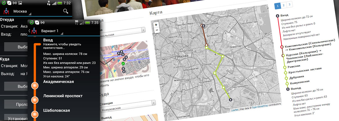
In order to use all of these were developed mobile and web applications, allowing you to quickly create several options for a route between entrance/station and station/out and shows what obstacles will meet on your way.
Despite the fact that initially the service is aimed at people with disabilities, I think it will be useful to ordinary citizens in some cases. For example, during transportation of oversized baggage in the subway (they now have the option "I am with the cart"), but the information is about escalators, ramps and ramps will be useful to cyclists (according to the rules you can transport the bike just "not working" condition, that is without the front wheel, though in fact the BMX ers, and the other comrades take it off), and mothers with baby carriages, tourists with suitcases and many others. Yes, and the information would be superfluous in any case.
In General project, in my opinion, very interesting and to develop it a lot. And when you consider that by August of next year in Moscow metro promises free Internet (Wi-Fi), everything appears in an even better light. So I wish you guys luck and success in the development of their project!
PS I Myself with the team NextGIS in no way linked, so if you find any bugs or want to share their impressions about the project write better here info@nextgis.ru. Although habré is present Maxim Dubinin: gislab so, share your experiences and comments.
Article based on information from habrahabr.ru
Details under the cut.
project Task
To give people with disabilities a convenient way to navigate through the subway with the marking of obstacles and restrictions to their movements.
Solution
To solve this problem, data were collected about the obstacles when moving all the metro stations of Moscow and St. Petersburg.
Including:
the
-
the
- places restricting passage (turnstiles, escalators, doors) the
- staircases the
- ramps and ramp (rails) the
- elevators
Compiled detailed maps of the locations of the exits of the subway based on open data and OpenStreetMap made, linking them to each other, significantly improving and clarifying the existing data.
Based on the collected data and information on the outputs of the analysis, what obstacles will meet the person at a certain exit of a certain station and exit on the other, as well as on transplants.
Has been drawn detailed diagrams of all stations with an indication of the obstacles (I have not yet found where to look, and that's the most interesting). But as the developers say:
We have made the scheme all the stations but they still require refinement. We will lay out the scheme gradually, whole lines, what will be reported in the news.
In order to use all of these were developed mobile and web applications, allowing you to quickly create several options for a route between entrance/station and station/out and shows what obstacles will meet on your way.
For all
Despite the fact that initially the service is aimed at people with disabilities, I think it will be useful to ordinary citizens in some cases. For example, during transportation of oversized baggage in the subway (they now have the option "I am with the cart"), but the information is about escalators, ramps and ramps will be useful to cyclists (according to the rules you can transport the bike just "not working" condition, that is without the front wheel, though in fact the BMX ers, and the other comrades take it off), and mothers with baby carriages, tourists with suitcases and many others. Yes, and the information would be superfluous in any case.
In General project, in my opinion, very interesting and to develop it a lot. And when you consider that by August of next year in Moscow metro promises free Internet (Wi-Fi), everything appears in an even better light. So I wish you guys luck and success in the development of their project!
PS I Myself with the team NextGIS in no way linked, so if you find any bugs or want to share their impressions about the project write better here info@nextgis.ru. Although habré is present Maxim Dubinin: gislab so, share your experiences and comments.


Комментарии
Отправить комментарий